
Roughly 14,500 kilometres of road, and one number on the shield. That is the whole idea behind the Big Lap Australia dreamers talk about at every caravan park camp kitchen: pick a direction, point the rig at Highway 1 and keep the ocean, or at least the coast, somewhere on your side until you roll back into where you started.
It sounds almost too simple. It is not. Highway 1 is not one road but a stitched-together network, and it has some of the loneliest stretches of bitumen on the planet. This is a look at what the route actually is, how it got its number, and why our team reckons the lap has become something close to a rite of passage for Australia's travelling retirees.
The longest national highway in the world
According to Wikipedia's entry on Highway 1, the network joins every mainland capital city except Canberra. At approximately 14,500 kilometres, it is the longest national highway in the world, ahead of the Trans-Siberian Highway at over 11,000 kilometres and the Trans-Canada Highway at 8,030 kilometres. Over a million people traverse some part of it every day, which tells you how much of it is ordinary working road before it turns into a long-distance dream.
The number dates from 1955, when the National Route Numbering system was adopted. Nobody built a ring road. The route was compiled from an existing patchwork of state and local roads and tracks, then given a single identity. It remains the only route to reach across all the Australian states plus the Northern Territory, and many of the other national routes are tributaries that feed into it.
That patchwork origin matters for anyone planning a lap. A road assembled from older pieces behaves like older pieces: freeway in one hour, two-lane country road the next, and in places something that barely looks like a highway at all.
The route, city by city
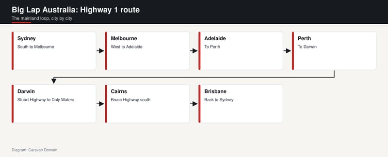
The loop is easy to say and long to drive. From Sydney it heads south to Melbourne, mostly along the Princes Highway, then on towards Adelaide. From Adelaide it runs to Perth, from Perth up to Darwin, and from Darwin across the Gulf country to Cairns. Then it swings south through Brisbane and back to Sydney.
The detail is where it gets interesting. Leaving Sydney, the route uses the Eastern Distributor and, further south, the Princes Motorway to Wollongong before returning to the Princes Highway along the NSW South Coast and into Victoria. West of Melbourne it follows the Princes Highway through Warrnambool and across the border to Mount Gambier. The Adelaide to Perth leg strings together the Eyre Highway across the Nullarbor, then the Coolgardie-Esperance Highway, South Coast Highway and South Western Highway. Heading north from Perth, it takes the Brand Highway, North West Coastal Highway, Great Northern Highway, Victoria Highway and finally the Stuart Highway into Darwin.
The return east goes down the Stuart Highway to Daly Waters, then the Carpentaria Highway to Borroloola, then a long unnamed link to Normanton, and on to Cairns via the Gulf Developmental Road and Kennedy Highway. From Cairns the route runs south to Brisbane via the Bruce Highway and Gateway Motorway. It then returns to Sydney along the Pacific Motorway and the Pacific Highway, finishing under the harbour through the Sydney Harbour Tunnel.
The stretch with no name
One section deserves its own heading. Between Borroloola in the Northern Territory and near Normanton in Queensland, Highway 1 follows a 715-kilometre run that is part of the Savannah Way but has no highway name of its own. It is a string of local roads: Wollogorang Road, Westmoreland Road, Doomadgee Road, Nardoo Burketown Road and Burketown Normanton Road. The source describes it as largely unsignposted.
Think about that for a moment. The longest highway in the world has a gap in the middle of its own story where the shield largely disappears and you follow the names of local roads instead. In our view that is part of the charm. It reminds you the lap is a route you assemble, not a conveyor belt you ride.
For anyone drawn to the really remote end of Australian travel, the same spirit runs through our features on the Gibb River Road, which is a very different beast from Highway 1 but shares the same pull towards the far corners of the map.
Where the Big Lap gets lonely
Road conditions on Highway 1 vary enormously. The source lists multi-lane freeways around populous urban and rural areas, sealed two-lane roads in remote places like the Nullarbor Plain, and single-lane roads in northern Queensland. Some stretches are very isolated. The Eyre Highway across the Nullarbor and the Great Northern Highway near the north-western coastline are named as examples, with isolated roadhouses often the only sign of human activity for hundreds of kilometres.
That is the romance and the warning in the same sentence. The same entry notes that Highway 1 has been described as a "death trap", particularly on two-lane sections in northern Queensland, because of driver fatigue. The long distances between destinations and the limited rest areas, especially ones suitable for trucks, contribute to the problem.
We are not going to pretend to be road safety experts, and nothing here is a substitute for official advice. What we will say is that a lap rewards a slow pace and a flexible calendar. If your plan only works when you drive tired, the plan is the problem. Check conditions and requirements with the relevant state road authority before each leg, and make sure your vehicle and van are properly matched, which is where our guide to what your car can tow is a sensible first stop.
Highway 1 is not the National Highway
A detail that trips up plenty of people: Highway 1 and the Australian National Highway are not the same thing. Large sections are shared, but where they split, Highway 1 follows the coast and the National Highway takes the inland, more direct line between major cities.
The Sydney to Melbourne example makes it clear. Highway 1 uses the Princes Highway down the coast. The National Highway uses the Hume Highway and Freeway through the interior. One is the scenic version, the other is the quick one.
For a Big Lap, that choice is the whole point. Anyone in a hurry has other options. The shield on the coast road is the one that sends you past beaches, forests and small towns, and the source describes the landscapes along the route as ranging from tropical to temperate gum forests, giant karri stands, scrubland, deserts and huge tropical swamps.
It also admits the lap is not quite the whole country. A drive around Highway 1 with a major detour to Uluru and back practically covers most of Australia, the entry says. Our team would add that this is where plenty of travellers decide their lap needs a side trip or two.
How grey nomads made it a rite of passage
In Australia, the slang term for a retired person who travels in a recreational vehicle is a "grey nomad". That is the definition the Wikipedia entry on recreational vehicles gives, and it is a good summary of the people we picture at the roadhouse on the Eyre Highway with the awning out and the kettle on.
The sources do not give lap statistics, so we will not invent any. What we can say, as an opinion, is that the ingredients lined up neatly. The same entry says RVs flourished in many western countries between 1945 and 1960 as disposable income and leisure time grew, and that dedicated parks were established for both short and long-term stays. It also says Australia developed pop-top caravans before the Second World War, with good ventilation, ample water storage and high ground clearance, features that suit a big, hot country. Highway 1 received its number in the same decade as that post-war boom.
Put a numbered ring road, a van built for the conditions and a stretch of free time after work together, and the lap more or less names itself. Our team reckons it has become the thing you say you will do someday, and then, for a lot of retirees, actually do. If that sounds like you, our feature on maximising your retirement travel is worth a read, and our state-by-state bucket-list caravan trips can help fill in the detours.
The shield that became part of the bush
The look of the route has changed over time. Originally the whole of Highway 1 carried a National Route 1 shield, black number on white. In 1974, segments declared part of the National Highway network switched to a National Highway shield, gold number on green.
Since then, the states and territories, with the exception of Western Australia, have adopted or are adopting alphanumeric route numbers. Much of the route now wears an M1, A1 or B1 marker, depending on the route's quality and importance. Tasmania was the first state to adopt alphanumeric numbers, yet its section of Highway 1 is still marked with the National Highway 1 shield. South Australia has replaced old "National Highway A1" and "National Highway M1" markers with the standard A1 and M1 shields.
This matters on a lap because the number you chase changes with the paddock. Follow the 1 in your head, but keep an eye out for the M, A and B in front of it. Western Australia is the one place that has not adopted alphanumeric route numbers.
The source puts it nicely: the number 1 shield became part of the bush landscape to many travellers, truckies and country people. It is a small piece of road furniture that has ended up meaning a great deal.
Seven days, three hours and eleven minutes
Not everyone does the Big Lap slowly. On 29 October 2023, Team Cobber Dingo set a new record for a complete lap of Australia. Earlier attempts included Team Highway 1 to Hell's time of 5 days, 13 hours and 43 minutes in a 200 Series Toyota Landcruiser, which skipped Tasmania's stretch of road. Team Cobber Dingo, two friends, did not omit any sections.
They began in Hobart at midday on 22 October 2023 and crossed Bass Strait that evening aboard the Spirit of Tasmania. The mainland portion started and finished at the old Ford assembly plant in Geelong, Victoria. A coin flip in the car park decided the direction, and it came up clockwise. The vehicle was a red 1998 Ford Falcon AU Series 1 Futura wagon nicknamed "Bill". Their elapsed time, including about ten hours on the ferry, was 7 days, 3 hours and 11 minutes.
We love that story, partly because it is the polar opposite of a grey nomad lap. One approach counts the minutes, the other refuses to. Both rely on the same black ribbon and the same number.
If you like your Australian travel history with a bit of dust on it, our feature on Francis Birtles, the overlander who drove Australia first makes a good companion read to a lap of the modern route.
Tasmania, the loop's loose end
Tasmania is easy to forget, and it is the one bit of the route that sits apart. There Highway 1 starts at the Brooker Highway in Hobart and heads for Launceston via the Midland Highway. At Launceston it becomes the Bass Highway to Burnie, where Highway 1 ends. The Bass Highway carries on to Marrawah on the west coast as Highway A2.
So the full Highway 1 experience means a ferry, and the Team Highway 1 to Hell example shows how that can be skipped in a speed attempt. For a relaxed lap, we would argue the island is where the lap earns its stripes, though that is our view and no fact from the record books.
However you do it, the mainland loop alone is a big commitment of time, vehicle and patience. If you are still weighing up the rig itself, our listings of caravans and RVs for sale are a handy place to browse while you decide how big your lap should feel.
Somewhere out there tonight, somebody is parking beside a roadhouse with a number 1 shield out front and wondering if they have another few thousand kilometres in them. Most of them do.
Sources
- Wikipedia, Highway 1 (Australia), accessed 15 November 2026
- Wikipedia, Recreational vehicle, accessed 15 November 2026