
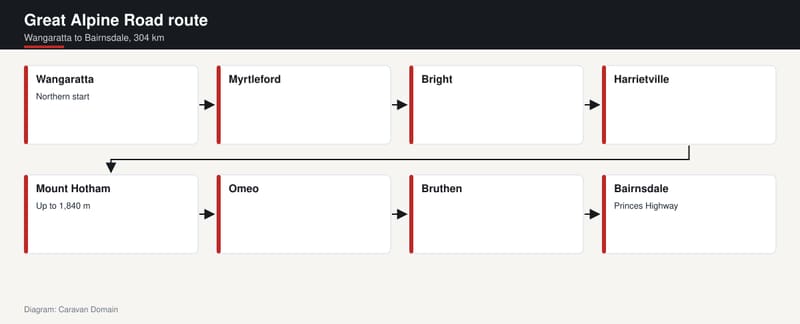
The Great Alpine Road runs 304 kilometres from Wangaratta in the north to Bairnsdale in the east, and it is described as Australia's highest year-round accessible sealed road. That is a big claim for a road that starts among vineyards and farms. It earns it somewhere around the 1,840 metre mark, on the shoulder of Mount Hotham, where the bitumen is buried in snow through winter and cleared by crews every day.
We love a road with a story, and this one has several. It has a name borrowed from a famous coastal cousin, a skiing supervisor who turned a cottage into a guesthouse, and a final stretch of seal that was only finished in the late 1990s. Here is how Victoria got a road over the top.
A road named as the mountain answer to the coast
The name tells you the ambition. According to the Wikipedia entry on the Great Alpine Road, it was given its current name because it was considered the mountain equivalent to Victoria's world-famous Great Ocean Road in the south-west of the state. If you want the other half of that pairing, we've already told the story of the Great Ocean Road as a memorial.
The comparison is a fair one in spirit. Both are drives that people plan a trip around, and both give a state a headline route to hang a holiday on. The difference is the scenery. Instead of surf and limestone, this road winds through mountains, valleys and forests, and past rivers, vineyards and farms.
It runs from Wangaratta to Bairnsdale, passing through the Victorian Alps. Our team reckons that sentence undersells it. A single road that links wine country, high snow country and the far end of the state at the Princes Highway is a lot of Victoria in one go.
Following the route from Wangaratta to Bairnsdale
Work through the towns in order and the shape of the trip appears. You leave Wangaratta, pass through Myrtleford to Bright, carry on to Harrietville, then climb over the mountain to Omeo. From Omeo the road heads via Bruthen to Bairnsdale, where it ends at the Princes Highway.
Those are the stages the road's own history is built from. The Wikipedia entry records that the original Bright Road, from Myrtleford to Bright, and Harrietville Road, from Bright to Harrietville, were declared Main Roads on 16 November 1914. The high section between Harrietville and Omeo came under the Country Roads Board in 1923. The southern part, from Omeo via Bruthen to Bairnsdale, was once the southern section of the Omeo Highway.
The pictures that the entry flags as notable sights give a feel for the variety. There is the view from Myrtleford towards Mount Buffalo National Park, and the descent of "The Gap" between Omeo and Swifts Creek. And there is the road itself, which is described as clinging to the side and ridge of Mount Hotham as it winds across.
The climb to 1,840 metres
The headline number is the road's high point. The section over Mount Hotham rises to 1,840 metres above sea level. The mountain's own summit is a little higher, at 1,862 metres, and the road sits on its slopes rather than at the very top.
Mount Hotham itself is in the Victorian Alps of the Great Dividing Range. It is approximately 357 kilometres north-east of Melbourne by the figures given in the Mount Hotham entry, and the nearest major road to it is the Great Alpine Road. It is named after Charles Hotham, Governor of Victoria from 1854 to 1855.
What stands out is how ordinary the road's role is here. This isn't a track for specialists. It is a sealed, signed state road that happens to climb into some of the coldest air on the mainland. In our view that is the quiet thrill of it: you can get into serious alpine country without leaving the bitumen.
Cold enough to rewrite the weather rules
The climate on top is the reason the road has rules attached. Mount Hotham is cold throughout the year, compared with most of Australia, and it is one of very few places in the country that frequently records maximum temperatures below freezing. It is the coldest weather station on mainland Australia by maximum temperatures.
Two details from the entry stuck with us. The mountain has never recorded a temperature above 30 degrees Celsius. In the early 2009 south-eastern Australia heatwave, while most of the state sweltered above 45 degrees, its peak was a mild 28.1. And snow turns up often: Mount Hotham averages 66.1 snowy days a year, and sub-freezing maximums can be recorded even in high summer.
Yet the entry also notes that, thanks to frequent winter cloud and the exposed position, a temperature below minus 10 has only occurred once since records began in 1990. So it is cold, but the very deepest cold is rare. Cloud and exposure are the story up there, and they are part of why the rules below exist.
Snow season, chains and closures
This is the part to read slowly, and then check with the official bodies. The road usually remains open during winter. But vehicles travelling between Harrietville and Omeo are required to carry diamond-pattern snow chains during the declared snow season.
The Mount Hotham entry says that season usually runs from the King's Birthday long weekend in June until the first weekend in October. During that time it is a legal requirement to carry diamond pattern wheel chains and fit them if directed, and there are penalties for not doing so. The steep and exposed portions of the road between Harrietville and Hotham Heights mean that in some conditions, particularly for two wheel drive vehicles, travel is not safe without them.
Extreme weather can still close the road between Harrietville and Omeo, even though it is cleared daily. Visitors also need to buy an entry permit to enter the resort in winter. The fee goes towards services such as ski patrol, the free village buses and snow clearing of car parks in the village. Resort land is managed by Alpine Resorts Victoria, so that is the body to ask about current requirements.
If you are thinking of bringing a van, keep it simple. Snow, steep grades and towing are a serious combination, and the right answer depends on your vehicle and the day. Start with our tow-match tool and the guide to what your car can tow, then check road conditions and the rules with the official road and resort authorities before you commit.
Bill Spargo and the cottage on the ridge
The human story on this road starts in 1923. That year the Country Roads Board, which had been set up under the Country Roads Act 1912, took responsibility for the Alpine Road between Harrietville and Omeo. It appointed William Benjamin Spargo, known as Bill (1888 to 1959), as supervisor.
Spargo lived in a stone cottage at Hotham Heights. At his request, the board expanded the cottage so it could accommodate up to twenty visiting skiers. From 1925 the premises operated as a guesthouse, Hotham Cottage, also known as the Hotham Heights Chalet. The Wikipedia entry calls it the forerunner of the Hotham Alpine Resort.
We find that a lovely bit of Australian road history. A government supervisor, a stone cottage and a few skiers who needed a bed became the seed of a whole alpine resort. Roads often do that; they create the reason for the place at the end of them. It is the same quiet logic behind the long lines we've looked at elsewhere, such as the Stuart Highway down the middle of the country, though the scale here is mountain rather than desert.
From Ovens Highway to Great Alpine Road
The road's paperwork is a small saga of its own. The Highways and Vehicles Act 1924 provided for State Highways financed two-thirds by the state government through the Country Roads Board. The Ovens Highway was declared a State Highway in the 1947/48 financial year, from Wangaratta via Myrtleford to Bright, a total of 47.5 miles. Before that, the road was also referred to as (The) Alpine Road. The highway was extended from Bright along Alpine Road to Harrietville in September 1993.
Then came the rename. Ovens Highway and Alpine Road, from Wangaratta to Omeo, along with the southern section of Omeo Highway from Omeo via Bruthen to Bairnsdale, became the Great Alpine Road in late 1996. The old State Route numbers, 156 and 195, which had been signed in 1986, were replaced with route B500. Under the Road Management Act 2004, VicRoads re-declared it as Great Alpine Road (Arterial #4005), beginning at Wangaratta Road at Wangaratta and ending at the Princes Highway in Bairnsdale.
It is dry reading, but it explains why the road feels like one long journey today. For much of its history it was a patchwork of separate highways and local roads with different names. Putting a single name on it turned it from a string of connections into a destination.
The last 12 kilometres of bitumen
The road has existed in some form since colonial times, but it was unsealed for much of its history. The final gap was the 12 kilometres between Dinner Plain and Horsehair Plain, which was completed in the 1997 to 98 financial year.
Think about that for a moment. The road was renamed in late 1996, and the very last piece of the sealed mountain route was finished the year after. A name that promised a great alpine drive arrived before the whole thing was properly paved. In our view that is a pleasingly Australian way to do it: announce the destination, then get the graders in.
It also helps explain the "highest year-round accessible sealed road" label. Sealing the top, and keeping it cleared of snow every day in winter, is what turns an old mountain track into something you can plan a trip around in any season. Not that every season is equal. A summer run through the high country and a winter run behind a snow plough are very different trips.
Why it belongs on the big list
Australia has no shortage of famous drives, and most of them are famous for emptiness. We've written about the big lap on Highway 1 and a good few outback tracks. The Great Alpine Road earns its place for the opposite reason. It is compact, sealed, and packed with change: vineyards at one end, snow country in the middle, and the Princes Highway waiting at Bairnsdale.
It also shows how a road gets made. A stone cottage, a handful of skiers, a few Acts of Parliament, some renumbering and a last 12 kilometres of seal all went into it. Not a single piece of that is glamorous, and yet the result is a sealed route over the Victorian Alps.
If you plan to go, treat the mountain with respect. Check the snow season dates, the chain rules and any closures with the official bodies, and be honest about what your vehicle and your van can handle. Then take the long way round, and let the road do the rest.
Sources
- Wikipedia, Great Alpine Road, accessed 22 November 2026
- Wikipedia, Mount Hotham, accessed 22 November 2026