
A road that was meant to run as straight as the barrel of a gun does not sound like a gentle thing to drive. The Gunbarrel Highway isn't. It is about 1,350 km of washaways, heavy corrugations, stone, sand and flood plains, and the last section of it reached Carnegie Station in Western Australia on 15 November 1958. We reckon it is one of the great stories of Australian road building, and it starts with one surveyor who liked a straight line.
His name was Len Beadell. Here is who he was, why the road exists, and what it asks of the four-wheel drivers who still go looking for it.
The surveyor who liked a straight line
According to the Len Beadell biography on Wikipedia, he was born in West Pennant Hills, New South Wales, in April 1923, and he was a surveyor, road builder, bushman, artist and author. By the time he finished, he had built more than 6,000 km of roads and opened up some 2.5 million square kilometres of central Australia between 1947 and 1963. People sometimes call him "the last true Australian explorer".
The bush was in his bones early. As a boy he joined the 1st Burwood Scout Troop in Sydney, where the scoutmaster, John Richmond, worked as a draughtsman and surveyor for the Metropolitan Water, Sewerage and Drainage Board. From 1931 to 1941 Beadell spent most weekends on bush survey trips, camping and hunting for old survey marks. He learned how to take astronomical sightings and use a theodolite. In 1938 Richmond took a group of six scouts to Lord Howe Island, where they worked out that the mapped position of the island was out by about 10 kilometres in latitude.
Not a bad apprenticeship for a teenager.
War came next. Beadell served in survey units, including in New Guinea, where he picked up drawing skills by watching army topographical draughtsmen. He stayed in the army after 1945 and volunteered for the survey team for a rocket testing range in outback South Australia, the project that became Woomera. In 1952 he selected a site for the secret testing of a British atomic bomb. In March 1953 he built a road from Mabel Creek to that test site, Emu Field. It was his first road, and it would not be his last.
Why anyone needed a road out there
Nobody cut a track through that country for the scenery. The Gunbarrel's own Wikipedia entry lists three reasons. The first was access for a future meteorological station, needed to forecast upper winds before atomic weapons were tested in South Australia. The second was instrumentation along the centre-line of fire for rockets launched from Woomera. The third was to let surveyors from the Australian Division of National Mapping carry on the geodetic survey of little-known parts of the outback.
The road was part of Australia's role in the weapons research establishment at Woomera, which also took in Emu Field and Maralinga. It was a weapons-research job with a very practical edge: you cannot forecast winds or place instruments in country you cannot reach.
There was a side effect. The finished road became the first east-west road link across the centre of Australia. A route built for rockets and weather ended up as a line on the map that had never existed before.
The name comes from Beadell's own outfit, the Gunbarrel Road Construction Party. He said he tried whenever possible to make the road as straight as a gunbarrel. Beadell had a famous sense of humour, and he called many of his roads "highways". The description stuck. Maps still show them that way, even though they have since degraded to single-lane unsealed tracks through remote arid country.
How the party actually cut a road
The method was simple on paper and brutal in practice. Beadell did the initial reconnaissance and survey himself, usually alone, pushing through raw scrub in a Land Rover. He used a theodolite to observe the Sun or stars and calculate latitude and longitude. Once the line was decided, a bulldozer followed to cut a raw track, clearing away the spinifex and mulga scrub to make a basic level surface. Then a standard road grader smoothed it.
That is the whole recipe: a surveyor out front, a dozer behind, a grader behind that. Everything else was supply lines, spare parts and nerve.
Beadell also left markers as he went. He set "astrofixes" along his roads, aluminium plates stamped with latitude, longitude and other information. Sadly, many have been taken as souvenirs, and a program is underway to replace them with replicas. If you ever see one on a remote track, leave it where it is.
For anyone who has read about the Canning Stock Route or the Simpson Desert crossing, the Gunbarrel sits in the same family of far-flung tracks. The difference is that this one was surveyed, bulldozed and graded as a deliberate engineering job, with the line chosen by a surveyor using the Sun and stars.
Stage one and two: bolts, roots and a bore
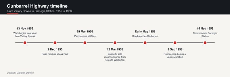
The road was built in four stages. In early November 1955 the party gathered near Coober Pedy in South Australia, half arriving from Adelaide with a bulldozer, half from Maralinga with a grader. The starting point was Victory Downs homestead, just north of the Northern Territory border and 24 km west of the Stuart Highway. Work began on 13 November 1955.
Trouble came quickly. After about 35 km the grader's blade mounting bolts snapped when the blade hit a submerged mulga tree root, and Beadell made a hurried trip back to Alice Springs for parts. The road reached Mulga Park on 2 December, where work stopped for the year because the bulldozer's starting pilot motor had failed.
He was not idle. Beadell pushed on with a ground reconnaissance, then flew an aerial survey on 7 December towards the Rawlinson Ranges, where the weather station was to go. A ground party of four Land Rovers followed, and a stone cairn went up on 12 December. The site was named Giles, after Ernest Giles, the first European to explore the area in 1874. On the way back, Beadell's Land Rover broke a rear axle, so the party borrowed one from another vehicle, which was left behind to be recovered the next year.
In 1956 the second stage ran from Mulga Park through the Musgrave, Mann and Tomkinson ranges, and the party reached Giles on 29 March. Beadell had hoped to pass Surveyor Generals Corner, but it was too rocky for road building. Then came water. A boring plant was fetched from a railhead 800 km to the east, and the grader slowly towed it to Giles. On the fourth drilling attempt they struck drinking water.
An unshared nightmare
No further work happened in 1957. When the third stage began, it started with a solo reconnaissance from Giles to Warburton on 12 March 1958, with the weather still very hot.
Beadell later gave the chapter in his book Too Long in the Bush a telling title: "An Unshared Nightmare". Daytime temperatures ran between 40 and 45 degrees Celsius. His engine overheated and the fuel vaporised. The heat melted plastic parts of his instrument panel and radio transmitter, and it loosened the nails in his boots until the heels fell off. He lost his appetite and drank only hot water.
His course took him along the southern edge of the Rawlinson Range, towards Lake Christopher, then south through the eastern edge of the Gibson Desert. He fought through a series of jumbled sand ridges, had three flat tyres, and found his water almost gone. Clear of the ridges, some rocky hills led him to a small pool in a creek run-off. According to the source, it saved his life.
He reached Warburton, rested three days, then returned to Giles by a different route.
Building the next section started on 22 March from Giles, kept north and west of his reconnaissance route to dodge the known obstacles. The road passed close to where Alfred Gibson was estimated to have perished, then turned south, and Warburton was reached by early May. The team also built a new airstrip much closer to the mission settlement.
Our view: that single trip tells you more about the man than any medal. Surveying alone, in that heat, with a vehicle that is slowly cooking, takes a particular sort of stubbornness.
Finishing at Carnegie, and 29 teeth
The fourth stage needed a change of plan. The survey from near Warburton to Carnegie was led not by Beadell but by H A (Bill) Johnson of the Division of National Mapping, who was responsible for the Australian Geodetic Survey in that area. Johnson and Beadell had both served in the Australian Survey Corps in the Second World War. They each drove a Land Rover in the advance party, followed by two more Land Rovers and a supply truck. The survey ran from 14 to 28 May, and during it a mountain was found. It was named Mount Beadell in his honour, and the Surveyor General of Western Australia formally named it in 1958. A cairn, a plaque and a replica of his theodolite now sit on top.
Construction of the final section began at Jackie Junction on 3 September 1958. The party was abeam Mount Beadell on 25 September, reached Everard Junction around 15 October, and arrived at Carnegie Station on 15 November 1958, just over three years from the start. The new road from Victory Downs measured 1,347 km.
There is one more detail we love. During a break in June 1957, Beadell talked a visiting dental surgeon at Woomera, Dr Bruce Dunstan, into giving him a crash course in tooth extraction. Days or weeks from any city, a toothache could stop a whole crew. His first extraction was in March 1958, on a cook named Cyril Koch. By 1963 he had pulled 29 teeth and joked that he had 29 notches on his forceps.
Roads named after the family
Beadell kept building after the Gunbarrel, by the same method, and named most of the roads after his family. The Connie Sue Highway honours his daughter, the Gary Highway and Gary Junction Road his son, the Anne Beadell Highway his wife, and Jackie Junction his youngest daughter.
Recognition followed. He received the British Empire Medal in 1957 for his work on the Gunbarrel, an Order of Australia medal in 1988 for "service to the Public service and to literature", and in 1994 he was named the Australian Geographic Society's Adventurer of the Year. An asteroid, 3161 Beadell, carries his name, because his roads led to the discovery of several important meteorites. A library in the City of Salisbury, Adelaide, was renamed for him too. He died on 12 May 1995.
Anyone wanting more of the story has plenty of reading. His first book was Too Long in the Bush, followed by titles such as Still in the Bush, Bush Bashers and Outback Highways. Mark Shephard wrote a biography, A Lifetime in the Bush, and Ian Bayly wrote Len Beadell's Legacy: Australia's Atomic Bomb and Rocket Roads.
The Gunbarrel Highway today
What is it like now? Still tough. The source describes the route as a long, hard haul through very remote territory, and says travellers must be completely self-sufficient with water, food and fuel. The longest stretch between fuel outlets is 489 km, between Warburton and Carnegie Station.
The road has also changed. A newer road, the Great Central Road, takes a more direct line, made possible by modern heavy equipment, and it has superseded some of Beadell's original tracks. Part of the Gunbarrel between Jackie Junction and Warakurna, near Giles, is now called the Old Gunbarrel Highway and is no longer maintained. Even so, all of his original roads still exist, and they remain popular with hardcore four-wheel drive enthusiasts.
Permits matter. The route runs directly through Aboriginal land, and travellers are legally required to hold a valid transit permit. The source lists three free permits in Western Australia and a separate permit for the APY Lands in South Australia. For the abandoned section between Warakurna and Warburton, permits require at least two vehicles and either an HF radio or a satellite phone, with a minimum of five working days' turnaround. Entry is only at Warakurna or Warburton, and access via Jackie Junction is not permitted because Jackie Junction Road is on sacred land. Rules like these change, so confirm the current requirements with the relevant land managers well before you leave.
Our team's view is that the Gunbarrel is better treated as a history lesson to respect than a box to tick. If you are weighing up what kind of rig suits tracks this rough, our page of off-road caravans for sale is a place to start, though the honest answer for the old Gunbarrel is that you plan for self-sufficiency first and the vehicle second. Prefer a gentler taste of remote country? The Gibb River Road has made its own bucket-list name.
Beadell wanted straight roads. What he left behind is a long, rough, wonderfully stubborn line across the desert, and it is still there for anyone prepared to do the hard yards.
Sources
- Wikipedia, Len Beadell, accessed 16 November 2026
- Wikipedia, Gunbarrel Highway, accessed 16 November 2026