
Two thousand, seven hundred and nineteen kilometres. That is the length of the Outback Way, a route that starts at Winton in Queensland, cuts through the Northern Territory, and finishes at Laverton in Western Australia. It is a string of existing roads, some sealed and some graded gravel, stitched together under one name and one very large idea: that the middle of the country deserves a proper cross-continent road.
The nickname is Australia's longest shortcut, and we'll admit it made us smile. A shortcut that long sounds like a contradiction. But on a map, with the coast roads sweeping the long way around, the logic starts to show.
This is a story about that route, how it is built, what it asks of travellers, and why a group of councils has been pushing for it for decades. Everything here comes from the public record, and we have not driven it ourselves.
What the Outback Way actually is
The Outback Way is also called the Outback Highway, and it links Laverton, Western Australia, with Winton, Queensland. It crosses three jurisdictions: Western Australia, the Northern Territory and Queensland. According to Wikipedia's entry on the Outback Highway, it is a series of sealed and unsealed roads rather than one purpose-built highway.
That detail matters. There is no single road authority running the whole thing. The project is described as a series of coordinated but separately funded projects, one each for Western Australia, the Northern Territory and Queensland. So a stretch of fresh bitumen in one state can sit alongside gravel in the next, because each government has its own budget and its own priorities.
The pitch behind it is simple. The Outback Highway Development Council is a non-profit alliance of local governments, and it lobbies for the sealing and upgrading of the whole route. Its aim is an inland link between southern Western Australia and northern Queensland, an alternative to National Highway 1 along either coast. If you have ever read about Big Lap Australia and Highway 1, this is the other idea: skip the rim and cut through the middle.
Eight roads, one route
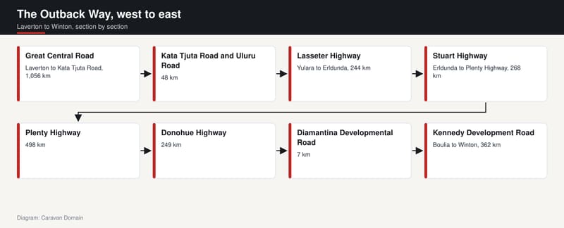
Walk the route from west to east and you pass through eight named roads. It is worth knowing them, because the surface changes with each.
The first and longest is the Great Central Road, around 1,056 kilometres of mostly graded gravel with short sealed sections, running from Laverton to the junction with Kata Tjuta Road near Yulara. Then come Kata Tjuta Road and Uluru Road inside Uluru-Kata Tjuta National Park, 48 kilometres between the Great Central Road and the Lasseter Highway.
The Lasseter Highway is sealed, 244 kilometres from Yulara to Erldunda on the Stuart Highway. The route then follows the Stuart Highway for 268 kilometres, from Erldunda to the Plenty Highway junction. That is the major north-south road through Central Australia, so for a while the Outback Way is simply riding on the country's main spine.
After that the gravel returns. The Plenty Highway is mostly unsealed and runs 498 kilometres to the Donohue Highway, which is also mostly unsealed, 249 kilometres to the Diamantina Developmental Road just north of Boulia. That road contributes only 7 kilometres to the route. Finally the sealed Kennedy Development Road carries you the last 362 kilometres from Boulia to Winton.
Notice the pattern. Sealed bookends in the east, a sealed middle in the Territory, and the long unsealed push in the west and through the Plenty and Donohue.
The Great Central Road and the Beadell connection
The western end has the richest history. According to Wikipedia's Great Central Road article, its origins lie in the early 1930s, when Warburton was established as a missionary settlement and supplies came from Laverton along a rough bush track. By the mid-1950s that track had become graded dirt.
Then the rocket range arrived. In 1958, during the survey for the Gunbarrel Highway as part of the Woomera rocket range project, Len Beadell visited Warburton and built a new road from Giles via the Rawlinson Range to Warburton. Jackie Junction, 69 kilometres north of Warburton, is where the Gunbarrel branched off towards Carnegie Station. If that name rings a bell, our piece on Len Beadell and the Gunbarrel Highway tells the wider story.
In January 1978 the Western Australian Government provided funds to the Warburton council to build a more direct road from Warburton to Docker River, bypassing part of the twenty-year-old Gunbarrel. The two roads are still coincident for 45 kilometres near Giles, and the Outback Highway entry notes that parts of the road around Warakurna run concurrent with the Gunbarrel too.
So when you read that the Great Central Road is a gravel track across the desert, remember it began as a mission supply line and then picked up a surveyor's work along the way.
A small note on numbers: the two sources do not quite agree on the road's length. One gives 1,056 kilometres to the Kata Tjuta Road junction, the other 1,126 kilometres to Yulara, so it pays to check distances against an official route guide before you plan your fuel.
Permits: the rule that catches people out
Here is a point plenty of first-timers miss. The Great Central Road passes directly through Aboriginal reserves, and it is a legal requirement to hold a valid transit permit at the time of travel, even when you stay on the road itself.
As of May 2026, the sources list three free permits. Laverton to Tjukayirla Roadhouse is applied for through the Western Australian Department of Planning, Lands and Heritage, and the application is referred to the Yilka Talintji Aboriginal Corporation. Tjukayirla Roadhouse to the Northern Territory border goes through the Ngaanyatjarra Council permit portal. Tjukururu Road, the Northern Territory section between the border and Kata Tjuta Road, goes through the Central Land Council.
Other sections are different. When you keep to the highway itself, permits are not required on the other parts of the Outback Way, and Queensland no longer requires permits for its sections at all.
There is one more administrative wrinkle in Uluru-Kata Tjuta National Park. The route passes through the park entry gate, where Uluru Road divides into a lane to enter, controlled by a barrier and the Park Pass payment office, and a separate exit lane with no barrier or stop sign. The Outback Highway entry says travellers should check with the National Parks office about whether a pass is required in either direction.
Rules change, so confirm every permit with the named agencies before you leave rather than trusting any article, ours included.
Fuel, phones and the long gaps
This is not a route for winging it. The Great Central Road article lists fuel at Laverton and Yulara at each end, plus three stops in between according to the Outback Way website as of May 2026: Tjukayirla Roadhouse, 300 kilometres from Laverton; Warburton Roadhouse, 560 kilometres from Laverton; and Warakurna Roadhouse, 786 kilometres from Laverton.
Look at those gaps. Hundreds of kilometres between the stops, and that is only the western section. Fuel availability and opening hours are the sort of thing to check with the route's official information, not to assume.
Phones are the other issue. The Outback Highway entry says mobile coverage is limited and non-existent for long sections, with reliable 4G found only in major hubs and near some roadhouses and Aboriginal communities. The Great Central Road entry recommends carrying communications equipment. Treat that as a hint to plan your communications properly before leaving a town, not at the first dead zone.
Weather can shut the whole thing down too. In 2024 the Great Central Road was closed for some months due to flooding. The route is out there in every sense, and road condition updates are the thing to check before each leg.
If you are weighing up what to pull behind you, our off-road caravans range is a place to compare rigs. Whether your particular car and van are suited to the gravel is a question for the manufacturers and the road authorities, not for a feature article.
Why the sealing campaign exists
A road this long needs a reason, and the numbers give one. According to the Great Central Road entry, the unsealed sections are graded to a standard suitable for two-wheel-drive vehicles and caravans. It sits on the most direct route from Perth to Uluru, and approximately 10,000 vehicles travel it each year.
That is a lot of traffic for a gravel track through the desert. It explains why the Great Central Road is described as being developed as the third east-west transcontinental highway across Australia.
The money is real. The Western Australian project between Laverton and the Northern Territory border is due to be completed in 2032, at a cost of A$678 million. It is the largest of the three state and territory projects. As of May 2026 the Great Central Road had 736 kilometres left to seal in Western Australia, and Tjukururu Road in the Northern Territory had 117 kilometres still to go.
Across the whole route, the Outback Highway entry says 1,161 kilometres were left to seal as of May 2026. Set against the full 2,719 kilometres, that is a fair chunk. Our team reckons it is the most honest measure of this road: it is both a finished highway in places and a work in progress in others, and that is part of its charm.
Sights worth a detour
The big names sit in the Northern Territory. The Great Central Road entry calls Kata Tjuta, also known as The Olgas, and Uluru the two most notable attractions on the road, both inside Uluru-Kata Tjuta National Park.
On the Western Australian side, the list is quieter and more interesting. Tjukayirla Roadhouse takes its name from the Tjukayirla rockholes, at the south-west end of the campground, and wildlife around it includes dingoes, emus, kangaroos, camels and many species of birds.
Empress Springs, or Reti, is a significant cultural site for the Ngalia people, on land subject to a native title claim. It is inside a cave, about 60 kilometres north along the David Carnegie Road, whose junction lies 15 kilometres west of the roadhouse. Access is via a chain ladder. A mural of the site, painted by Deeva and Kado Muir in 2018, appears on Kalgoorlie Police Station.
History lovers get the Paine and Barclay Survey Marker, erected in 1931 by surveyors Harry L. Paine and Hugh C. Barclay on their expedition to the Warburton Ranges. The closest rockhole to it is Winduldarra Rockhole. The source also lists Lasseter's Cave, the Petermann Ranges, Giles Weather Station, the ochre bluff of Giles Breakaway, Lake Throssell, Lake Yeo Nature Reserve, and Peegull Waterhole and Caves.
One practical item for anyone heading west towards Laverton: there is an amnesty bin for Quarantine WA 20 kilometres outside the town. All passenger vehicles are to stop and dispose of quarantine risk material listed on the sign, including fresh fruit, vegetables, honey, seed and potatoes, and there is a risk of fines if you are stopped carrying it.
A shortcut, or a long way round?
Is it really a shortcut? In our view the nickname is a cheeky bit of marketing that happens to be true on the map. Draw a line from northern Queensland to southern Western Australia and the Outback Way is the direct one, with the coastal highways bowing around it. Whether it is quicker in a caravan on corrugations is another matter, and we would not promise it.
What it does offer is a different kind of trip. Other desert routes are expeditions in their own right; our pieces on the Canning Stock Route and the Simpson Desert crossing cover tracks that demand serious preparation. The Outback Way sits at a gentler point on that scale, since parts are sealed and the Great Central Road is graded for two-wheel drive and caravans, yet it still threads the continent's interior.
It is also a project still being built, with sealing due to run to 2032 and 1,161 kilometres to go. Travellers who cross it now will see a road halfway between what it was and what its backers want it to be. For a country that likes to say it has finished the job of mapping itself, there is something good about a highway that hasn't been finished yet.
Winton to Laverton, then. A long way, a long shortcut, and a decent reason to open the atlas.
Sources
- Wikipedia, Outback Highway, accessed 16 November 2026
- Wikipedia, Great Central Road, accessed 16 November 2026